Moscow Stories episode 3
Moscow
The Hidden Shape of Public Transport. The third episode of the Moscow stories involves a research study carried out during 2013 and presented the same year at the Moscow Urban Forum, thanks to the invitation of its curator and architect Yuri Grigoryan. This study has been also published in the “Archaeology of the periphery” book, the research project led by Grigoryan and consisting – as a key outcome of the forum – in a condensed series of articles aiming to reveal the latent potential of our cities, focusing the attention on the relation between Moscow urban center and its urban fringe, through the lens of many international urbanists.
In recent years, the Moscow conurbation has experienced rapid expansion and transformation. Due to the growth rate of the urban landscape, the city is facing today a loss of identity; it is becoming more and more difficult to control the territorial expansion of the built environment. This ongoing process affects the quality of life that the city itself can offer to its users. Among the several factors that determine the livability of a great modern city, the availability of high quality transport infrastructure certainly plays a primary role; this must be conceived in terms of accessibility to the entire population and the rapid connection between places, maximizing opportunities for citizens and businesses that ‘live’—every day—the wider and wider territory.
Moscow is a clear example of a monocentric urban morphology, where both the transport network and the land use distribution are focused on the central part of the city, that is the main attractor. The radial axis system and orbital paths are reflected in the road fabric as well as in public transport. The current transport scheme was planned and developed over time, based on the assumption that all demand for mobility gathered towards the city center. Following these principles, the urbanized territory of Moscow has been shaped into “super-functional blocks”, accessible by few roads (characterized by large sections) which serve as connections to the big areas, otherwise inaccessible. Such a configuration clearly affects traffic flow; the limited availability of roads cannot allow for proper vehicular circulation. As a result, the few large connections and rigid patterns of circulation are often congested by immense traffic jams, reflected by longer trip times, slower speeds and increasing vehicular queuing.
Location
Moscow
Client
Moscow Stories episode 3
Main expertise
Movement Analysis; R&D
PROJECT HIGHLIGHTS
- Authors: Federico Parolotto, Francesca Arcuri
- The video is the results of an additional investigation that puts Moscow in comparison with other four similar cities worldwide: Istanbul, Sao Paulo, Tokyo and Paris.
Project gallery
Our contribution
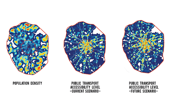
From the images, it is clear that Moscow is endowed with a low number of inhabitants in the central part of the city, whereas the “donut,” as it is called, contains the vast majority of city dwellers.
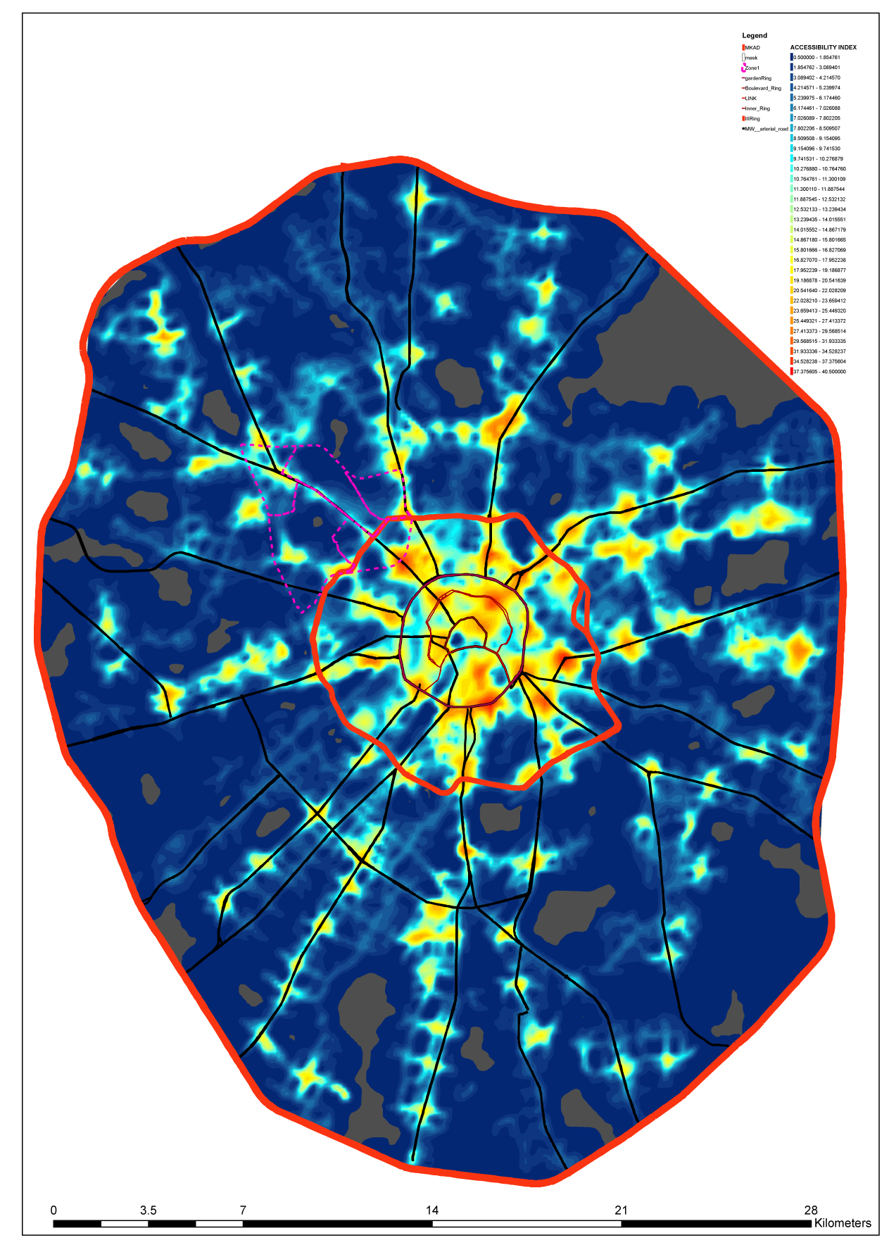
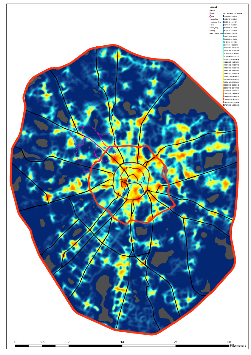
This demographic distribution generates a strong commuting pattern that can only be balanced by introducing services and tertiary functions in the donut, together with the increase of residents in the central part of the city. Such land use redistribution will need to be coupled with public transport hubs serving the new relations and the map of Public Transport Accessibility Levels (PTAL) allows bringing to the surface the hidden shape of public transport in the city, both for the existing and the possible future scenario.
In this framework, it is the topology of public transport that will be the driver of land use densification and redistribution; the contours of the PTAL maps will help defining planning policies that will not generically locate land use in the proximity of public transport, but that will rather respond to the specific “shape” of public transport densities. The future of Moscow will need to address the way transport operates today by reducing private car usage, enhancing public transport connectivity together with more intelligent land use redistribution.
In order to achieve meaningful results of the video, a set of large dataset has been collected and elaborated with GIS software. Starting from the perception of residential distribution and densities throughout selected metropolitan areas, the analysis consists in bringing together the physical and spatial correlation between accessibility to public transport and residential densities patterns. By adopting this approach, it is possible to highlight the clusters of highest residential densities characterized by good public transport accessibility level.
This research, carried out through a virtual investigation of the transport-related dynamics affecting today’s Moscow metropolitan area, brings to the surface some latent layers of information of urban context. The traditional way of addressing capacity in cities, that has led for instance to the once powerful one way traffic system typical of central Moscow, needs to be revised in favor of sustainable transport modes. A strong focus used to be given to motorists, but it is now clear that the metropolises of the western world are progressively going through a process of space and time redistribution, a process aimed at giving a more balanced distribution of various modes of transport.
A viable path towards sustainable cities is defined by the need of reducing the space given to the automobile or by introducing other appropriate policies for vehicles entering the city centre. In this regards, examples of policies in actions are Les Berger project in Paris, where part of the express way alongside the Seine has been closed to cars in favor of a public space, as well as London, and more recently Stockholm and Milan, where the introduction of a congestion charge has dramatically reduced the amount of vehicles entering the city centre.