Fine Networks: a New Approach to Sustainable Urban Mobility
Moscow
In one of his latest books “Transport for Suburbia: Beyond the Automobile Age”, the sustainable mobility expert, Australian Paul Mees, presents the idea that every transit user is, inevitably, also a pedestrian at some point in their journey. Actually, over the course of the day, everyone invariably ends up being a pedestrian. Even if only for a minute. Even if only for a short stretch of road. In terms of its implications and significance, this simple and incontrovertible truth has been neglected for decades. The main element that most—if not all—contemporary cities have in common is, in fact, the predominance of automobiles over all other entities living and moving in the urban environment.
The dynamics that engendered this widespread condition differ according to the various geographical areas. In Western countries, the rapid growth of car ownership in the first half of last century triggered a priority shift in urban planning processes, in which the focus was transferred from the person to the automobile.
It is now internationally recognised that, strategically speaking, an approach to private transport infrastructure planning based on maximising vehicular capacity is doomed to failure. This is due to the production of rapid saturation with consequent congestion. Nevertheless, until very recently this is what happened in departments of transport and urban planning, where the needs of space-hungry cars were satisfied at the expense of public space and pedestrian areas, based on a progressive expansion of the area destined for automobile usage by subtracting from social space.
Emerging in the Western world in opposition to this trend, is an awareness of the impact that a massive vehicular presence has on all aspects of life in the urban context (environment, health, economy, etc.). As a direct result of this, new strategies, targeted policies and redevelopment projects are spreading in the international arena. Attention is being refocused on the original relationship between space and movement in urban and transport planning; a relationship that was lost for years due to the monofunctional erosion of urban space in favour of express vehicular connectors, typical of old line transport engineering.
In the overall framework discussed thus far, it is also undeniable that the idea of planning for sustainable mobility is often associated with measures aimed mainly at favouring the use of non-motorised modes of transport, of which the bicycle is obviously foremost. The bicycle—in all its possible forms (human-powered or electric, privately owned or shared)—is becoming the new protagonist of sustainable mobility, together with the increasingly popular systems of sharing. The resultant increase in bike paths and mobility-on-demand stations (even though they are still rarely integrated into a truly holistic vision on an urban scale, enabling the full potential of the project to be realised) is to be applauded, yet it’s clear how the theme of walkability seldom becomes a central issue for policymakers and planners, or even ordinary citizens. Urban redevelopment or planning measures often reflect the (distorted) perception of citizens and policymakers alike, in which the pedestrian world is connected to non-systematic movements and free time more than to work-based activities, which are, rather, associated with modes that can ensure faster and more efficient movements.
Location
Moscow
Client
Fine Networks: a New Approach to Sustainable Urban Mobility
Main expertise
Data Analysis; Publications
PROJECT HIGHLIGHTS
- Authors: Federico Parolotto, Francesca Arcuri
- First published as Reti Sottili – Un Nuovo Approccio alla Pianificazione della Mobilità Urbana Sostenibile, in “AR Architetti Roma” – Rivista dell’Ordine degli Architetti, Pianificatori, Paesaggisti e Conservatori di Roma e Provincia, n° 113 Ottobre 2015
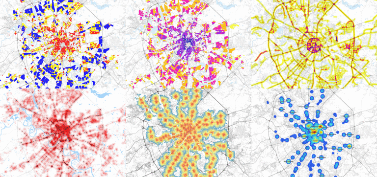
Project gallery
-
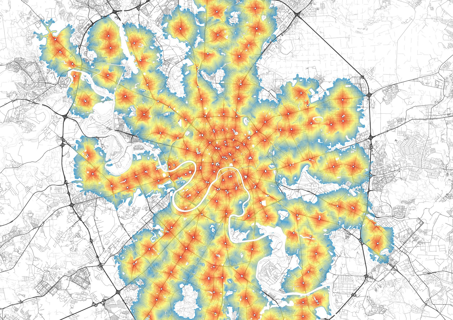
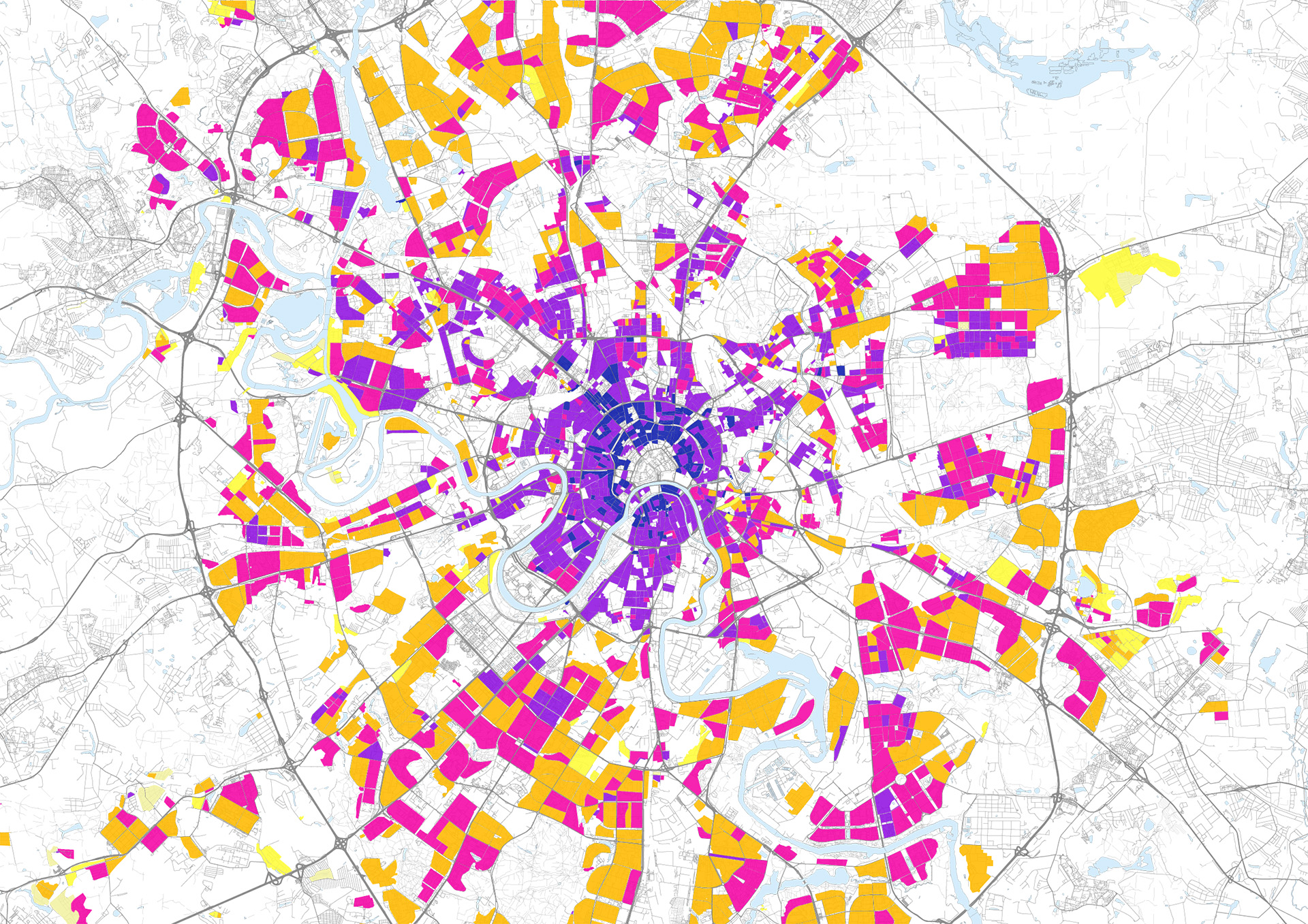
GIS analysis for the Moscow Pedestrian Masterplan study - built area mapping by blocks’ size
-
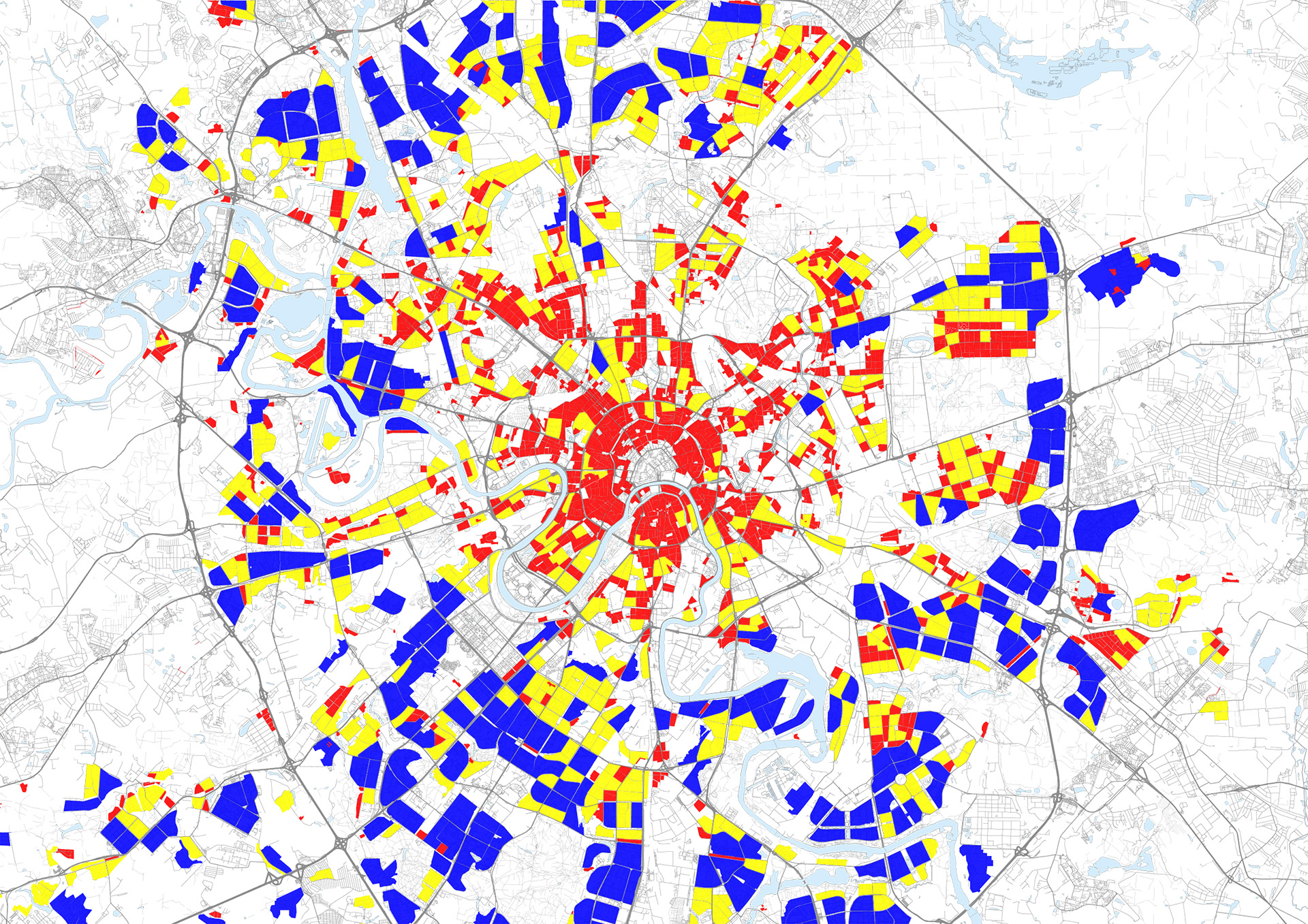
GIS analysis for the Moscow Pedestrian Masterplan study - built area mapping by coverage index
-
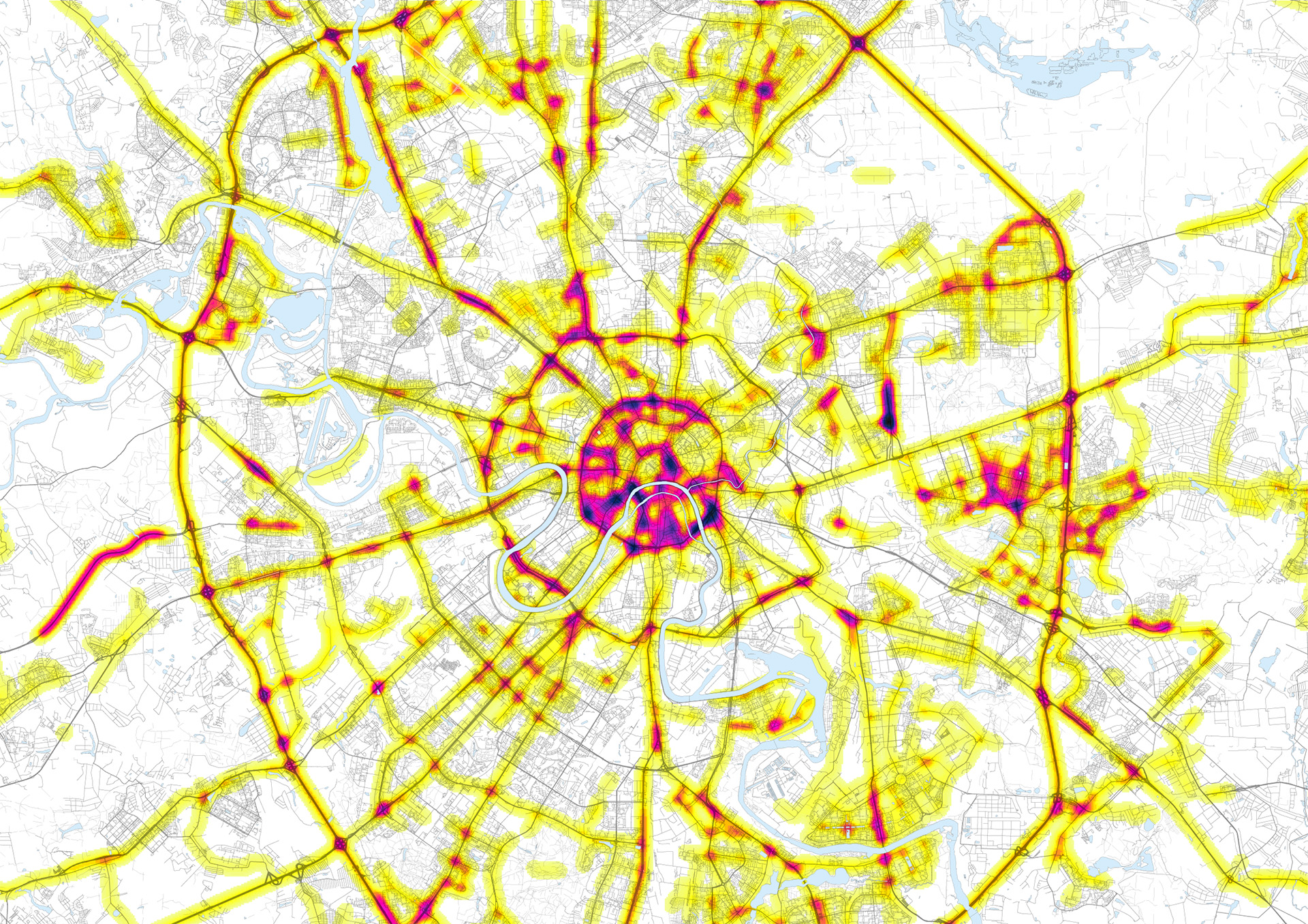
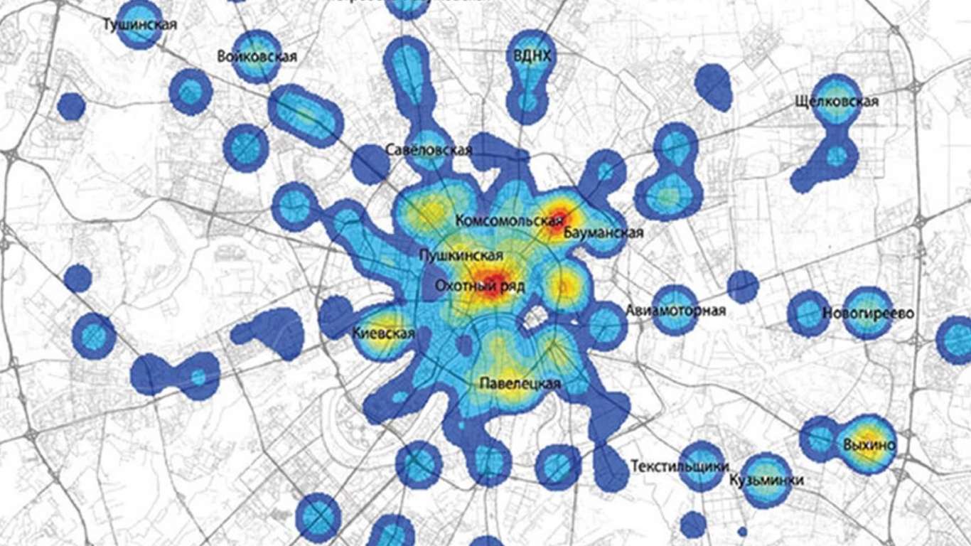
GIS analysis for the Moscow Pedestrian Masterplan study - built area mapping by density of vehicular lanes as indicator of infrastructural barriers
-
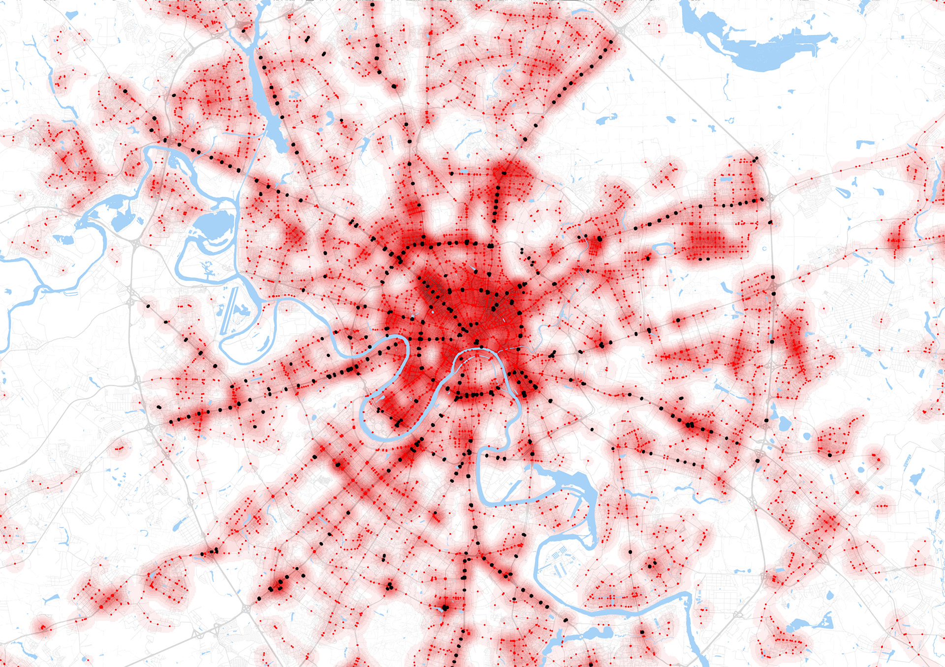
GIS analysis for the Moscow Pedestrian Masterplan study - built area mapping by density of pedestrian crossings
Our contribution
Pedestrian movements are at the base of the concept of mobility, understood as the agent’s relationship with the context in which it moves. Mobility means creating a relationship with the environment and experiencing its effects while going from A to B. This is always the case, however, the act of walking inevitably exposes us the most, and renders us a more active part of our surroundings. This is one of the reasons why the history of walking is the most complex of all, even in our contemporary cities.
Actually, it’s even more complex in contexts that are not generally ready to embrace and promote it. Clarification is also required here: often cities that are currently unable to assure pedestrians a high quality connected network, did so in the past. Examples like Milan, whose historical centre and old urban fabric outside the Spanish walls, consisting of internal courtyards traversed by walkways, offered the pedestrian a completely different reading of the road grid. Or, looking abroad to the clearly car-centred city of Moscow, where city blocks seemingly beyond human scale concealed an additional level of walkways and interior spaces, positioned halfway between the public and private; a series of courtyards which, before being transformed into fairly legitimate parking spaces as a result of an explosion in car ownership in the early nineties, supplied highly granular connections to those pedestrians who wanted to challenge the climate and the distances typical of the Russian capital.
These networks, which could be defined as “fine” in so far as they are free from heavy infrastructural features, are based, rather, on functional synergies between the elements of the urban context. They are now being rediscovered: re-emerging where already existing in some way, and generated, or sought out, where absent.
The concept of fine networks, with reference to the world of transport planning, can be enriched with new possibilities by reinterpreting the discipline with the fresh eyes of those who want to pursue a truly holistic and multimodal approach to designing solutions for future mobility.
That said, the possibility of working directly on some elements of the road network, such as traffic light systems, opens important scenarios for mobility specialists, bringing the matter literally and figuratively to a level that is already an integral part of the urban context—that is, the road—but endeavouring to reconfigure it based on multiple users, whose flows must be managed and optimised in a balanced way.
This type of intervention fosters the emergence of a new reading of the urban grid, creating “fine networks” that serve to reconnect the spaces within the sphere of pedestrian mobility to the urban scale.
The revision of traffic light phases, aimed at the recalibration of waiting times for pedestrians along specific routes, becomes the key to concretely and significantly transforming the road environment into a not only car-centred area. As a consequence of a specific distribution of functions, spaces and points of origin and destination, routes overlap and mesh by following and accommodating the desire lines of people moving within the space.
This concept emphasises an indisputable difference between the world of fine networks and that of traditional transport networks: the former act on an almost virtual level, enabling the creation of downstream relationships and connections, and the implementation of minimally invasive measures in mobility management; the latter, however, have always relied upon the creation, or modification, of infrastructures, thus passing from what is essentially a manipulation of time, to a physical alteration of space.
Acting on the space of our cities—often already dense, and even more often marred by the excessive infrastructuralisation of past decades—by working on an invisible time-based layer that avails itself of the latest technologies of our digital society, such as the incredible access to data, becomes an integral part in meeting the needs for sustainable mobility, which is the challenge for the coming years.
As an example of how the appearance of these “fine networks” is becoming more widespread, we can refer to the project carried out in collaboration with the Moscow Department of Transport, which, upholding a dynamic and innovative vision of mobility, in 2014 requested a study for the development of an urban plan to render the whole city pedestrian and bike friendly.
MIC-HUB’s work has been based on an intense analytical study of the existing conditions—carried out through GIS analyses—optimising all the different layers of information affecting the definition of pedestrian connections: infrastructural barriers, land use, signalised intersections, pedestrian crossings, accident data, green spaces. The information was organised in a single database and optimised for the purpose of comprehending both the criticality and potential of the existing network. Following this initial activity, a set of guidelines applied to a number of focal points enabled us to complete the framework needed to create a pedestrian connective fabric of high standard, in terms of comfort, safety and functionality.
Measures to redistribute and thus balance road space usage, in parallel with a careful synchronisation and downward revision of the traffic light cycles, enabled us to redesign the connections of the Muscovite network areas exemplified.
When considering Rome, we make a sizable geographical leap. The shift, however, is not so sizable in terms of context, with reference to the city’s status as one of our largest and most complex metropolises, with clear issues linked to usage of the existing road network. At the same time, Rome is also projected towards the implementation of policies and solutions directed at protecting “vulnerable” road users. Both of these types of measures—that is, dynamic signalising and designs for pedestrian connections—could be aptly and effectively applied in the case of the Roman Tiber riverfront.
In fact, considering the south-north tract that leads from Testaccio up to Tor di Quinto, almost half the vehicular bridges exhibit remarkable discontinuity in terms of the definition of pedestrian routes along the Tiber. For the most part they are signalised intersections, characterised by designs contingent on the express circulation of vehicles. They do not assure pedestrian crossings, if not at the expense of significant detours with respect to the pedestrian origin-destination pairs, and waiting times that relegate the experience of walking as secondary to the continuity assured to cars. A reconnection of the urban fabric could be guaranteed both east and west of the river, with a slight intervention in traffic mobility management and traffic lights which react in a dynamic and active way, based on the real-time network situation, and which, technologically speaking, are already available to us.
It is within this framework that we set the pilot project developed in 2015 for the AUDI Centre for Urban Studies and the municipality of Somerville, Boston, MA. As heads of the mobility strategy, we worked within the real context of Greater Boston’s innovative automotive technology, which networks the data supplied by circulating vehicles and the infrastructure. This synergy generates enormous possibilities for flow optimisation—and hence also optimisation of time and space—using a smart traffic lights system, which not only impacts the redistribution of vehicular routes, but also the possibility of prioritising all other modes of transport (from public to cycling), including pedestrian mobility. Thus, the stated objective is to plot the fine networks that are present in every city, but generally hidden.
Both the Moscow and Boston projects are characterised by the same objective: to plot new “fine networks”, which constitute the basis for a new design practice linked to the development of sustainable urban mobility.